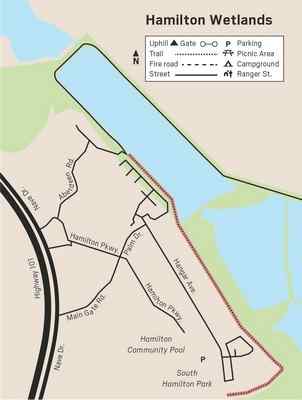
Hamilton Wetlands
January, when ducks and shorebirds are abundant, is an interesting time to
take this 21/4-mile walk alongside restored wetlands in Novato. One of the
newest parts of the San Francisco Bay Trail, this friendly path is busy with
people walking dogs, moms pushing babies in strollers, young children just
learning to ride two-wheelers with training wheels and older folks with
canes who enjoy the benches available for rest stops. While not everyone
takes advantage of the birding opportunities, in my view the proximity to
the restored wetlands is what makes this trail so special.
In the late 1800s, before the ecological value of wetlands was understood,
many wetlands were diked and converted to farmland. The Swamp Lands Act of
1850 encouraged landowners to drain wetlands in return for ownership of the
land. The San Francisco Bay lost 95% of its wetlands. It was not until the
Wetland Protection act of 1972 that some of the provisions of the Swamp
Lands Act were changed.
From the 1930s to the 1970s this area was the site of Hamilton Airforce
Base, named in 1932 for Lloyd Andrews Hamilton who died in action in France
during World War I. It was an active training facility during World War II.
In 1974, the base was decommissioned.
Restoration of the wetlands was a joint project of the U.S. Army Corps of
Engineers and the California State Coastal Conservancy. Congress authorized
the restoration in 1999. Years of work led up to the dramatic breaching a
levee in 2014 that reconnected 648 acres of wetlands to the bay and restored
tidal action in the area.
Today birds like the endangered snowy plover nest in the restored wetlands.
Birders can enjoy wading birds like great blue herons, American avocets and
black-necked stilts, along with flocks of ducks. When you see a group of
sandpipers suddenly all take to the air, look up to see if you can spot a
peregrine falcon on the prowl. Check on posts or other perches for a Say’s
phoebe, a flycatcher that, unlike its year-round cousin the black phoebe,
arrives in September and is with us only for the winter. Western bluebirds
and white-crowned sparrows like to perch on the fence that separates the
path from the wetlands. |
|
 |
|
At the one-mile mark there are benches and a display panel. As you look at
the display, keep in mind that the American avocet is pictured in breeding
plumage, with a lovely rusty-orange neck. Right now, they are in winter
plumage and you’ll be looking for black, gray and white birds that are the
same shape with an upturned bill. Note the sign that there is an agreement
for walkers to use restrooms in one of the hangers, a 1/3-mile detour.
When you reach signs saying the path is closed for construction, you can
enjoy one last treat by taking the trail to the left to see a pond that is a
favorite hang-out for dabbling ducks like the Northern shovelers. Because
the male has a bright green head, some people confuse male shovelers with
male mallards. The rich brown color on the sides, and the oversized bill
that gives shovelers their name, are good field marks. Unlike mallards,
which usually feed head-down, tail-up, shovelers swim with their heads
partly under water, filtering out tiny seeds, crustaceans and insects.
After perusing the pond, return the way you came, keeping in mind that if
the tide has turned you may see a different cast of characters on the way
back. For an audio tour of Hamilton Wetlands that you can download to your
phone, search for Hamilton audio tour.
From Highway 101, exit at Nave Drive. Stay on Nave Drive and turn right onto
Main Gate Road. From Main Gate Road (eastbound) turn left onto South Palm
Drive, then right onto Hanger Avenue. Parking is on the right, near a
playground. Dogs on leash or under voice control allowed, maximum three dogs
per person. Motorized wheelchairs allowed.
Wendy Dreskin has led the College of Marin
nature/hiking class Meandering in Marin since 1998, and teaches other nature
classes for adults and children. To contact her, go to wendydreskin.com.
source
|
