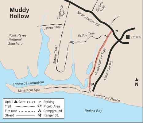
Muddy Hollow to Limantour Beach
If you’ve been avoiding the Muddy Hollow trail because of its inauspicious
name, you’re missing a lovely, level trail. Now, before the rains come, is a
great time to take this easy 1.5-mile
trail to Limantour Beach. Before the trail was realigned and reopened in
2011, the creek did appropriate the trail in the winter months. Since the
trail has been moved out of the floodplain, the seasonal muddy sections are
fewer and smaller.
The trail starts out as a paved road paralleling Muddy Hollow Creek, so it
is lined by water-loving plants and trees. Alders, with their white bark,
often make Easterners think of birch trees which are in the same family. The
tree has both male and female catkins. This time of year you can see the
brown female catkins that have already opened to release their seeds, like
conifer cones, as well as new closed green ones. Twinberries have their
paired dark berries now, but the bright red bracts remain. Bracts are
modified leaves that can be more brightly colored than the actual flowers,
often serving to attract pollinators. Bougainvillea, poinsettia and Indian
paintbrush are examples of flowers with brightly colored bracts that are
often mistaken for petals. Though the berries are not edible for people,
many birds enjoy them.
Soon the paved road becomes a trail, sometimes entering a tunnel of trees,
sometimes sunny. Keep an eye out for tule elk that were transferred to this
area from the Tomales Point reserve in 1999. Unlike the tule elk in that
fenced reserve, these elk are free ranging as their ancestors were. Tule elk
were very nearly hunted to extinction after the Gold Rush, and Point Reyes
is the only national park where visitors can enjoy viewing this endemic elk.
You are most likely to first spot the white of a female’s rump, or a bull’s
antlers poking up above the coastal scrub, perhaps resembling sticks from a
distance. Tule elk were named for a sedge that grows in wetlands, and soon
you’ll come to a fine example this favored elk habitat. Tules were important
to the Miwoks who once lived at Point Reyes. Tules were used for everything
from kotcas (houses) to boats, skirts, and baskets. Looking at a great egret
peacefully fishing in the estero downhill from the elk, I am reminded that
they, too, were once extirpated from Marin. Great egrets were hunted for
their plumes, which were used in women’s hats. At the height of the feather
trade they sold for more than their weight in gold. Imagine the excitement
of the people who discovered the first egrets seen in decades on Bolinas
Lagoon and Drakes Bay in 1929. I am so grateful to protected areas like our
state and national parks for giving these once-endangered animals a chance
to recover and once again thrive. |
|
 |
|
The trail continues to Limantour Beach, named for Jose Yves Limantour, a
French trader who ran his schooner Ayacucho aground on Limantour spit in
1841. He managed to salvage the cargo, and through sales and barter acquired
another schooner, Star of Oregon. When he was arrested for fraudulent land
claims in 1857 he posted bail, but then returned to Mexico where he died in
1885. Later, in 1849 and 1853, two other Marin sites were named for
shipwrecks, Duxbury Reef and Tennessee Cove.
Return on the same trail. Not including a stroll on the beach, the hike is
three miles round trip.
Take Sir Francis Drake Boulvard and turn right on Highway 1. In about 100
yards turn left turn on Bear Valley Road. Continue for approximately 1.3
miles, then turn left onto Limantour Road. Turn right at the signed Muddy
Hollow trailhead.
Wendy Dreskin has led the College of Marin
nature/hiking class Meandering in Marin since 1998, and teaches other nature
classes for adults and children. To contact her, go to www.wendydreskin.com
source Marin IJ |
