Rush Creek Bahia
With almost 200 species of birds and a unique forest that includes blue oaks
and blue oak hybrids, Rush Creek Open Space, an uncrowded 522-acre preserve,
is an exciting place to hike.
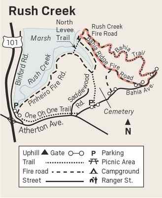
This 3.9-mile loop starts on Bahia and Rush Creek trails with views
of the tidal wetland and loops back through the blue oaks on the Bahia Ridge
Fire Road. With a sharp-eyed friend from the California Young Birders Club
along, we tallied 74 species in under three hours on this hike. If you are,
or know, an interested young birder, check out californiayoungbirders.weebly.com/bay-area-chapter.html.
Like so many of our beautiful open spaces in Marin, this one was nearly
developed. In the 1960s two brothers who were developers had a plan to build
2,500 homes there. After they built 250 houses, they ran out of money. The
area was bought by a second developer in late 1970s. After a referendum in
which Novato residents voted in favor of saving the land as open space, and
a protracted legal battle, Friends of Bahia and Marin Audubon managed to
raise the money needed to keep the area from being developed. With help from
the North American Wetlands Council, Marin County Open Space, the California
Native Plant Society, the Bay Institute, and others, Marin Audubon purchased
632 acres of land in 2003 — 208 acres of oak woodland were given to the
MCOSD and 361.7 acres of diked baylands were given to the Department of Fish
and Game to manage.
Marin Audubon kept the area which needed to most work, including removing
junked cars, trash, and many invasive African, Asian and European weeds, and
restoring the area by planting native plants. In 2008 the first levee
breeched, restoring 160 acres to tidal action.
Right from the start of the hike you will see deciduous oaks. Black oak
leaves have pointed lobes, while blue oaks have very shallow rounded lobes.
A California endemic, the blue oaks are drought adapted, able to survive
temperatures over 100 degrees with as little as 15 inches of rain per year.
Their blue-green leaves have a waxy coating to prevent the loss of moisture,
and they can even become dormant in extreme conditions. |
|
 |
|
The trail follows the edge of the wetland, giving hikers ample opportunity
to observe both shorebirds and waterfowl. One of the shorebirds I never tire
of seeing is the graceful American avocet. Most common in the fall and
winter, this gray and white bird swings its upturned bill from side to side
like a scythe as it sifts insects and small crustaceans from the water and
mud. Surprisingly, they also eat aquatic and marsh plants. Many nest in the
South Bay, but they have been observed breeding in Marin since 1983.
Breeding birds get a beautiful burnt orange head and neck.
The smallest of the dabbling ducks, green-winged teal males have a
cinnamon-colored head with a bright green patch. They breed as far north as
Alaska and work their way south to California over several months, with
numbers peaking in the Bay Area in October or November.
When you reach a diked area on your right with mechanisms to control the
flow of water, stay on the fire road as it veers left, and take the first
fire road on your left. This unmarked fire road starts out going fairly
steeply uphill. Ignore small use trails, staying on the fire road until a Y,
where you go left. This upland area is great for woodpeckers, nuthatches,
cedar waxwings, wrens and sparrows. There are several snags on your right as
you head downhill that acorn woodpeckers are using as granary trees. Bahia
Ridge Fire Road takes you down to trail that parallels Budgeia Lane where
you turn left for about a block to get back to your car. Dogs on leash
permitted, maximum three per person.
From Highway 101 in Novato, take the Atherton Avenue exit east for about one
mile. Turn left on Bugeia Lane, which becomes Bahia Drive. Follow Bahia to
the end. Trailhead is on the left.
Wendy Dreskin has led the College of Marin
nature/hiking class Meandering in Marin since 1998, and teaches other nature
classes for adults and children. To contact her, go to wendydreskin.com.
source |
