Headlands
As you walk this five-mile moderately
strenuous loop in the Marin Headlands with its sweeping views of San
Francisco and the Bay, imagine a city of 18,000 to 30,000 people living in
50 apartment towers, garden apartments, and townhouses, plus a mile-long
mall, and 250 acres of light industry. This what Thomas Frouge, in
partnership with Gulf Oil, had planned for these hills. As I watched a
coyote cavort across the trail and up a hill, and admired red-tailed hawks
soaring overhead, I was once again grateful to Edgar Wayburn, the Golden
Gate Headlands Committee, the Nature Conservancy, and all the
environmentalists who worked so hard to make sure this development never
materialized.
MARIN HIKING > MORE TRAILS
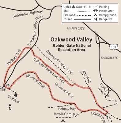
The hike starts on the Marincello trail, actually a fire road. Shortly after
Marin County approved the development in November 1965, stucco entry gates
were built at the foot of what was to be a main boulevard in and out of the
development. Longtime Marin residents remember the happy day in 1976 when
the Park Service finally bulldozed the gates to Marincello.
Marincello Trail is a steady climb of about 800 feet but you’ll be too busy
admiring the views to notice. As you ascend, you get panoramic views of
Angel Island, the Tiburon Peninsula and across the Bay to Mount Diablo.
After 1.5 miles, there is a respite and the trail levels out. Parts of San
Francisco come into view, and a corner of the Golden Gate Bridge peeks from
behind a hill. Across the valley on your right you can see Hill 88, where
the radar tracking dome for the Nike missile system was located, and one of
the old Nike missile sites.
A 60-foot high white structure is the recently renovated historic balloon
hangar at Fort Barry. It was built in 1921 when the army was experimenting
with having two soldiers in the wicker basket below a balloon relay
corrections via a phone line to the gun battery firing shells. The idea was
abandoned the same year. Since then the structure has had many uses, most
recently as a horse riding arena. After the renovations, it will become a
much-needed storage area for park vehicles.
There is no sign saying Alta Trail where you turn left, but you’ll see one
right after the turn, confirming you are on Alta Trail. In minutes you’ll
have a spectacular view of the Sausalito waterfront. Continue half a mile to
Oakwood Valley Trail and turn left, descending, fairly steeply in some
places, to Tennessee Valley Road. There are stairs on part of the Oakwood
Valley Trail. In the 1880s, Oakwood Valley was called Bear Valley. While the
three other ranches in the Tennessee Valley area were cattle ranches, the
Oakwood Valley ranch raised chickens. |
|
 |
|
One common shrub along this trail is the cotoneaster from China. Its red
berries may make some hikers think of toyon, or Christmas berry, which is
native and also grows on these trails. Birds enjoy the berries of both
shrubs, and spread both the native toyon and the invasive cotoneater. One
easy way for beginners to tell them apart right now is that the toyon
berries are still green. They get red closer to Christmas, hence their name
Christmas berry.
Cross the paved road to pick up the signed Rhubarb Trail on the other side.
It parallels a creek that the Park Service and Google maps do not name. If
any readers know a name, please email me. In a mostly shady .7 miles you are
back to the parking lot at the end of Tennessee Valley Road.
From Highway 101 take the Mill Valley/Stinson Beach/Highway 1 exit. Follow
Shoreline Highway north and turn left on Tennessee Valley Road. Dogs are
only allowed on some sections, so the loop is not dog-friendly.
Wendy Dreskin has led the College of Marin
nature/hiking class Meandering in Marin since 1998, and teaches other nature
classes for adults and children. To contact her, go to wendydreskin.com
source |
