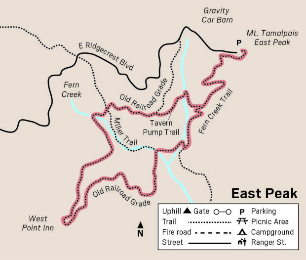
Mount Tamalpais South East Peak loop
| When you arrive at Mount Tamalpais’ East Peak
parking lot to start this 3.4-mile loop,
picture a train full of sightseers arriving at the station in 1896. Imagine
elegant ladies in long dresses and fancy hats accompanied by men wearing
three-piece suits, the gold chain of their pocket watch draped through a
buttonhole. As you pick up your backpack with a water bottle and sandwich,
visualize these passengers walking to the tavern to dine on fine food like
filet mignon with mushrooms, and later heading over to the Pavilion to
dance. You can learn more about the history of the railroad by stopping at
the Gravity Car Barn before or after your hike. It is open from noon to 4
p.m. on weekends.
Fern Creek Trail leaves from the parking lot. When you start out hiking
through chaparral you may wonder, as I did, where the creek and ferns could
possibly be. Have patience — they are closer than you think. Meanwhile enjoy
views to the south and the chaparral flora. Chemise is in bloom, and
manzanita berries are ripening now. If you appreciate detail, you may notice
small red “sausages” on the edges of manzanita leaves. These are galls
caused by aphids. If you find yourself wondering who put that shiny red nail
polish on the manzanita leaves, you have found manzanita leaf fungus.
The trail descends steeply and in .4 miles you will come to a water tank
and building that houses the Tavern Pump. In addition to needing water for
the Tavern, the trains needed water to cool their wheels. The trains had to
stop for water at Mesa Station and Fern Canyon. The pump still provides
water to East Peak today.
The trail crosses Fern Creek on a bridge, and you realize why the name is
apt after all. Chain ferns grow along the creek and bracken grows along the
trail. In winter, you would see goldback ferns, maidenhair and California
polypody as well, but they are dormant now during the dry season. |

|
Follow the creek down to Old Railroad Grade, another .3 miles, and turn right
toward West Point Inn.
Old Railroad Grade is partly shaded, thanks to redwoods, Douglas firs and tan
oaks. Toyons have small green berries now that will ripen in December, giving
them their other name, Christmas berry. Some springs provide muddy areas on the
trail for butterflies to puddle. I saw males of two species of blues getting
minerals from the mud, echo blues and the even smaller Acmon blues with their
¾-inch wingspan.
In a mile you reach West Point Inn, built in
1904. Here visitors arriving by stage from Stinson Beach could get refreshments
before boarding the train to East Peak. You can get refreshments as well —
lemonade and snacks are available every day except Mondays. The deck with its
busy hummingbird feeders, as well as the restrooms, are open to the public seven
days a week.
Continue the hike on Railroad Grade where shrubs such as sticky monkeyflower,
peak rushrose and yerba santa are still in bloom. Some fledgling chestnut-backed
chickadees were fluttering their wings and noisily begging parents for food.
Both parents continue to feed fledglings for three to four weeks after they
leave the nest.
I came across an “eyebrow” signed “Damaged Area, Keep Off, Stay On Trail.” I
always find it distressing when I see our trails vandalized by cyclists in this
way. On some trails on Mount Tamalpias it is all too common, and this sign was
clearly being ignored as there were fresh tracks.
In about .9 miles from West Point Inn, turn right on Tavern Pump Road which
takes you back to Fern Trail and in .4 miles back to East Peak Parking lot to
complete the loop.
- From Highway 101, take the Stinson Beach/Highway l exit in Mill Valley.
- In 2/3 mile turn left, staying on Highway l.
- After 2.6 miles, bear right at fork, onto Panoramic Highway (sign says Mt.
Tamalpais).
- After l mile, at the four-way intersection, take the high road, Panoramic
(sign says Mt. Tam).
- Continue 4.5 miles to the junction with Pantoll Road.
- Turn right and drive about 1.5 miles to the “T” at Ridgecrest.
- Turn right, and drive three miles to the end of the road.
Paid parking is $8, $7 for seniors.
|

