Mountain Theater Loop
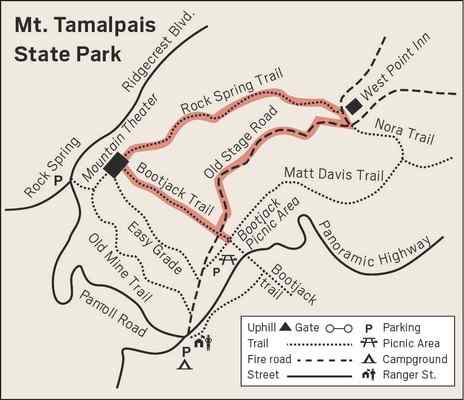
This 4-mile loop on Mount Tamalpais takes in the Mountain Theater and
West Point Inn, both much-loved sites steeped in local history, and
has great views of the bay to boot. Starting from Bootjack, the hike goes up
Bootjack Trail to the Mountain Theater, northeast on Rock Spring Trail to
West Point Inn, and returns on Old Stage Road.
From the picnic area, head up the Bootjack Trail with its rather steep
start. At the paved road, turn left and follow the road as it makes a
180-degree turn, and then make an immediate left where the sign says 0.5
miles to the Mountain Theater. A right turn at a sign that tells you you’ve
just come up the Bootjack Trail leads you to the stage where so many magical
productions have delighted audiences since the first play in May 1913. Many
Marin residents have their favorite moments at the theater — Maria
descending from the top of the theater singing “The Hills are Alive” as “The
Sound of Music” opens, the World War II-era plane flying over in “South
Pacific,” and the children flying in “Peter Pan.” Plays have been produced
there continuously since 1913 with the exception of 1924, when there was an
epidemic of hoof and mouth disease, and the years during WWII when the army
was stationed at the top of Mount Tamalpais.
Walk up the stairs from stage right to the water fountains, and turn right.
There is a bench near Pohli Rock, named for Austin Ramon Pohli, a student
from UC Berkeley who was the first production manager and tragically died a
few days later in an accident in Yosemite.
As you walk the 1.6 miles on Rock Spring Trail to the West Point Inn,
imagine the people who took the ferry from San Francisco and rode “The
Crookedest Railway in the World” to West Point Inn to see one of the early
plays. Picture them walking this last mile to the theater, the ladies in
their long skirts and boots, meeting up at the amphitheater with the more
energetic theater-goers who had walked the eight miles from Mill Valley
instead of taking the Mt. Tam Railroad. |
|
 |
|
The Rock Spring Trail passes over streams that still have a bit of water and
are green with California spikenard and chain ferns, and through areas of
chaparral with its mix of manzanitas, chemise and chaparral pea. The hoary
manzanitas with their gray-green leaves grow in particularly beautiful
shapes, making me think of bonsais. I also love this trail for the
spectacular views of Mount Diablo, San Francisco, Angel Island and the
Tiburon Peninsula. By the time a sign announces it is 0.4 miles to the West
Point Inn, you’ll probably already have spotted it.
The West Point Inn, so named because it was the westernmost point of the
railroad, was built in 1904. You can picnic on the veranda, enjoy watching
Anna’s hummingbirds at the busy feeder, and supplement your sandwich with
granola bars, lemonade, hot chocolate and other drinks.
The signed Old Stage Road takes you back to Bootjack. Several wet areas on
the fire road are the sites of what I call “puddle parties,” where you can
see over a dozen male butterflies drinking the water with minerals that they
need for their reproductive system. The California tortoiseshells hibernate
as adults, emerging in warm days in February or March to lay eggs on wild
lilac. That generation of butterflies will head up to the Sierra, Klamath
Mountains or the Cascades. At the end of September or early October,
suddenly they appear, back in Marin for the winter.
When you see the trail you took up to the Mountain Theater on your right,
retrace your steps back to Bootjack.
From Highway 101, take the Stinson Beach/Highway l exit in Mill Valley. In
2/3 mile turn left, staying on Highway l. After 2.6 miles, bear right at
fork, onto Panoramic Highway (sign says Mt. Tamalpais). After l mile, at
four-way intersection, take the high road, Panoramic (sign says Mt. Tam).
Pass Mountain Home and continue to Bootjack parking lot, 897 Panoramic
Highway.
Wendy Dreskin has led the College of Marin
nature/hiking class Meandering in Marin since 1998, and teaches other nature
classes for adults and children. To contact her, go to wendydreskin.com.
source Marin IJ |
