Northern Sierra Nevada, Sierra
County has a total population of just over 3,000. The old Gold Rush
Highway (Highway 49) meanders along the North
Fork of the Yuba River through the historic
towns of Downieville and
Sierra City.
(On your way through, be sure to check out the
gallows in Downieville, near the
courthouse.)
Just past
Sierra City, visitors enter the Lakes Basin
Area, which offers more than 50 clear
alpine lakes for fishing, swimming and boating. Much of the
area lies within Tahoe and
Plumas national
forests.
|
Plumas County
Sierra City
Sierra County Chamber,
Downieville campsites,,
(877) 444-6777
Mountain biking, http://www.YubaExpeditions.com/
|
|
Though
cabin reservations can be scarce
during the summer, many have openings after mid-August; the
lakes are still warm, the fishing good and you can enjoy the
warm days and cool nights of Indian summer. (Most
cabins close
for the season mid-October.)
Camping sites, part of the Tahoe
National Forest, abound along Highway
49 and the
North Yuba River, beginning before
Downieville and continuing through
Sierra City.
Along
Gold Lake Road, many more campsites
pop up along the lakes and creeks. These campgrounds have running
water, vault toilets and cost $18-$24 per
night, with a 14-day limit.
You can find a list of them at
plumascounty.org, or call (877)
444-6777 for reservations. |
|
For mountain-biking
enthusiasts, Yuba Expeditions,
yubaexpeditions.com, offers shuttles to the many local mountain
biking trails. |
|
At
Packer
Lake Lodge, you’ll find rustic charm with rough beams and
wagon wheel lights, lanterns and fresh flowers on the tables. During
the summer, a Wednesday night Italian buffet
is followed by Bingo that starts at 6
p.m. Be sure to call for reservations. (Closed Tuesdays.)
Sardine Lake
Lodge, on one of the area’s most picturesque lakes, also
offers dinners in a rustic cabin setting. Call way ahead for
reservations.
Gray Eagle
Lodge serves dinners in its majestic high-ceilinged
building.
The Sierra City General Store
is famous for Larry’s “gut-buster hamburgers,”
a favorite for hikers stopping off from the
Pacific Crest Trail. The store also stocks camping supplies. |
|
The
Pacific Crest
Trail winds
through this area, and the hiking
possibilities are endless with hikes for all skill levels.
Maps are available through the Tahoe National
Forest or the Sierra County Chamber of
Commerce.
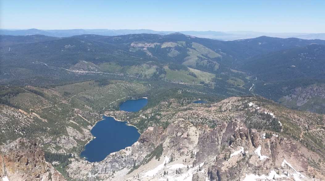
The Sierra Buttes, the rugged and
craggy peaks that jut up from the surrounding tree-lined hills,
reach an elevation of 8,700 feet at the summit
lookout tower. To hike the
Buttes trail, visitors
drive to a parking area and begin part way up, so don’t be
intimidated by how high they look from the road. The hike is best
done early in the day. The view is worth the effort.
Allow three to four hours for the climb. If you’re wary of
heights, skip the last minute of the ascent, up the stairs of a
former fire lookout station.
After you’ve hiked back down, head to
Bassett’s
Station for a well-deserved ice cream cone. They
also serve breakfast and lunch and old-fashioned milkshakes that
arrive at your table in a frosty metal container. |

Sardine lake from Sierra Buttes Fire Lookout
|
| |
|
| |
|
|

|


