|
San Ramon to Martinez
Rail right-of-way becomes successful
Bikepath, instead of Light Railway.
District stepped in when
residents rejected light rail
Aug 14th 2004 SF Chronicle
Some of the district's projects aren't bosky woodlands or recreational sites
they're critical public infrastructure. Foremost among these is the
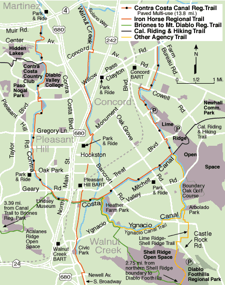
Iron Horse
Trail, a bike route between San Ramon and
Martinez.
"This was originally the right of way for the
areas main railway,
and a lot of public works folks wanted to
build a mass transit light rail system on it,"
said Steve Fiala,
the district's trails development manager, on a recent bike ride down the Iron
Horse.
"But folks who lived along the right of way and there are a lots of them weren't necessarily thrilled at the
prospect of rail traffic rolling up and down their backyards,"
said Fiala. "They just felt the area would
be a lot better served by a paved bike and foot trail.
They
began organizing seriously, (EBATC), (
Rail-to-Trails :
Funding excel,
Funding html
)
( Redlands Rail to Trail ) about 20 years ago, and
eventually the district got involved."
Ultimately the region's municipalities all
signed on to the bike trail idea, cashiering the light rail option.
Paving on the right of sway began in piecemeal fashion in 1986. Now, 18 years
and $15 million in federal, state and local
funding later,
the trail is paved from
Concord to
Dublin, with the exception
of a minor gap around the Pleasant Hill BART station. That will be addressed later this year,
said Fiala. making the trail a single 22
mile ribbon of asphalt and concrete wending past shadowed creeklands, pleasant
suburbs and upscale malls.
But a funny thing has happened from concept to execution. The trail was
originally envisioned as a leisure activity resource something that would be
used by locals looking to get a little exercise on their road bikes or settle
their meals with a postprandial stroll.
Instead, said Fiala,
"It has become a major
biking commute route, a way for people who live between Martinez and
Pleasanton to get to and from work During rush hour, a lot of people tell us,
it's quicker to bike 10 or 15 or 20 miles on the trail rather than fight the
traffic jams on Interstate 680." |

The completed trail will span the distance from Livermore in Alameda County to
the shoreline of Suisun Bay in Contra Costa County, a distance of 33 miles,
connecting two counties and 12 cities. |
An informal survey of riders and hikers seems to concur,
"I use it every day," said Pete Nunes, who bike commutes between his home in a
Concord trailer park to a Home Depot training class. "Without it, 1'd have to go
miles farther;' said Nunes. 'It'd take me more than 30 minutes. With the trail,
it's less than 10 minutes. It's essential to my life."
Joanne Rusca, who lives in central Walnut Creek, employs the trail to get to
local supermarkets and malls.
"Everyone around here uses it for shopping,"
she said. "With the trail handy, it
doesn't make sense to use a car. The traffic and the parking are terrible. If
you walk or bike, you can avoid all that."
|
|
|

